
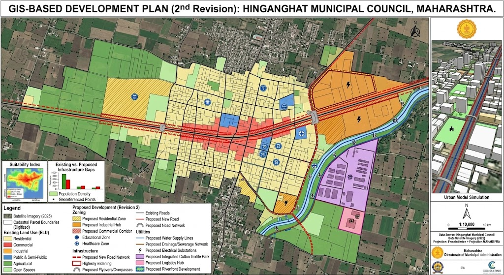
The GIS-Based Development Plan (2nd Revision) for Hinganghat Municipal Council is a 720-day project initiated in 2026 under the Maharashtra Regional and Town Planning Act, 1966. It maps land use and infrastructure to guide urban growth, providing a 10–20 year roadmap for sustainable, tech-enabled development in Wardha district.
Key Highlights
- Comprehensive Mapping: Integration of GIS technology to create precise digital maps for land use, roads, and infrastructure.
- Statutory Planning: Formulation under Sections 21-31 of the Maharashtra Regional and Town Planning Act, 1966.
- Infrastructure Optimization: Includes detailed land plans and land schedules for roads to improve connectivity.
- Strategic Growth Focus: Aligns with long-term regional planning to manage urban sprawl and land use efficiency.
Impact
- Evidence-Based Decisions: Provides accurate, location-specific data for planners to make informed infrastructure decisions.
- Streamlined Administration: Assists in better tax mapping and management of municipal resources.
- Sustainable Development: Enables spatial planning that balances industrial growth, residential needs, and environmental preservation.
Future Scope
- Smart City Integration: The GIS data acts as a foundation for implementing smart traffic systems, optimized waste management, and GIS-based property assessments.
- Regional Integration: Potential integration with the Nagpur-Wardha regional corridor planning to link Hinganghat with larger economic hubs.
- Development Plan 2030/2040: Ensures a structured, long-term blueprint for growth, aiming for enhanced industrial and residential development over the next 10-20 years.